Variable-Scale Maps
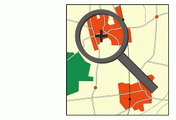
Today, users can access maps at any time and at any place via the Internet. Services like Google Maps or Bing Maps offer multiple possibilities for interaction. In particular, users can zoom or pan in order to define the area mapped on screen. Depending on the scale (or zoom factor), a map is selected from a small set of maps; the selected map is shown to the user. When zooming in, another map may become selected and displayed, which implies abrupt changes. This often causes users to lose orientation.
In a project funded by the German Research Foundation (DFG) (Ha 5451/3-1; 2012–2015), we develop algorithms for automatic generation of variable-scale maps. A variable-scale map may either be (i) a continuum of maps that covers a certain interval of scale or (ii) maps whose scale varies over the plane. When generating such maps, special quality criteria and constraints have to be taken into account. Algorithms for continuous generalization, dynamic label placement, and map schematization are needed. We will formalize these tasks as optimization problems and, thereby, we will make the quality of variable-scale maps measurable. In order to solve these problems, we will develop exact algorithms and heuristics for real-time applications.
Publications
Labeling streets along a route in interactive 3d maps using billboards.
In Proc. 18th AGILE Int. Conf. Geograph. Inform. Sci. (AGILE’15), Lecture Notes in Geoinform. and Cartography, pages 269–287. Springer-Verlag, 2015.
N. Schwartges, B. Morgan, J.-H. Haunert, and A. Wolff.
[doi]
Labeling streets in interactive maps using embedded labels.
In Proc. 22nd ACM SIGSPATIAL Int. Conf. Advances in Geograph. Inform. Systems (ACM-GIS’14), pages 517–520, 2014.
N. Schwartges, A. Wolff, and J.-H. Haunert.
[doi]
How to eat a graph: Computing selection sequences for the continuous generalization of road networks.
In Proc. 22nd ACM SIGSPATIAL Int. Conf. Advances in Geograph. Inform. Systems (ACM-GIS’14), pages 243–252, 2014.
M. Chimani, Th.C. van Dijk, and J.-H. Haunert.
[doi]
Interactive focus maps using least-squares optimization.
International Journal of Geographical Information Science, 28(10):2052–2075, 2014.
Th.C. van Dijk and J.-H. Haunert.
[doi]
Drawing Road Networks with Focus Regions.
IEEE Transactions on Visualization and Computer Graphics (Proc. Information Visualization 2011), 17(12):2555–2562, 2011.
J.-H. Haunert und L. Sering.
[PDF] [BibTeX]
Constrained set-up of the tGAP structure for progressive vector data transfer.
Computers & Geosciences, 35(11):2191-2203, 2009.
J.-H. Haunert, A. Dilo und P. van Oosterom.
[doi] [PDF] [BibTeX]
Algorithms for Interactive Variable-Scale Maps.
DFG Project Report, 2015.
J. Haunert, Th.C. van Dijk, and A. Wolff.
[PDF]