03.02.2020
Informatik-Kolloquium
Im Wintersemester 2019/2020 findet auf Einladung von Prof. Andreas Nüchter der folgende Vortrag statt:
Montag, 3. Februar 2020, 16.15 Uhr, Turing-Hörsaal, Informatikgebäude, Am Hubland
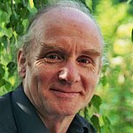
Prof. Dr.-Ing. Wolfgang Förstner
Institut für Geodäsie und Geoinformation
Universität Bonn
Mapping from Moving Platforms with General Cameras
Abstract:
Simultaneous localization and mapping from unmanned aerial vehicles has advanced in the last two decades allowing mapping large areas with a high point density. This is due to (1) improved computer power allowing camera systems with larger or stereo images and the exploitation of optimal estimation strategies and (2) integration of additional or alternative sensors, e.g. inertial sensors bridging times of large platform rotations causing image blur or event cameras yielding sharp images even at high speeds. In a first instance, the used cameras follow the classical perspective model.
We discuss generalizations of this model for the use of fisheye cameras, rolling shutter cameras and generic camera systems, as they occur when using stereo camera systems or cameras in under water applications, where in all cases light rays outside the platform do not necessarily intersect in a common point. We address the calibration, the camera orientation and the mapping with such cameras and show application examples.
Homepage:
http://www.ipb.uni-bonn.de/people/wolfgang-forstner/